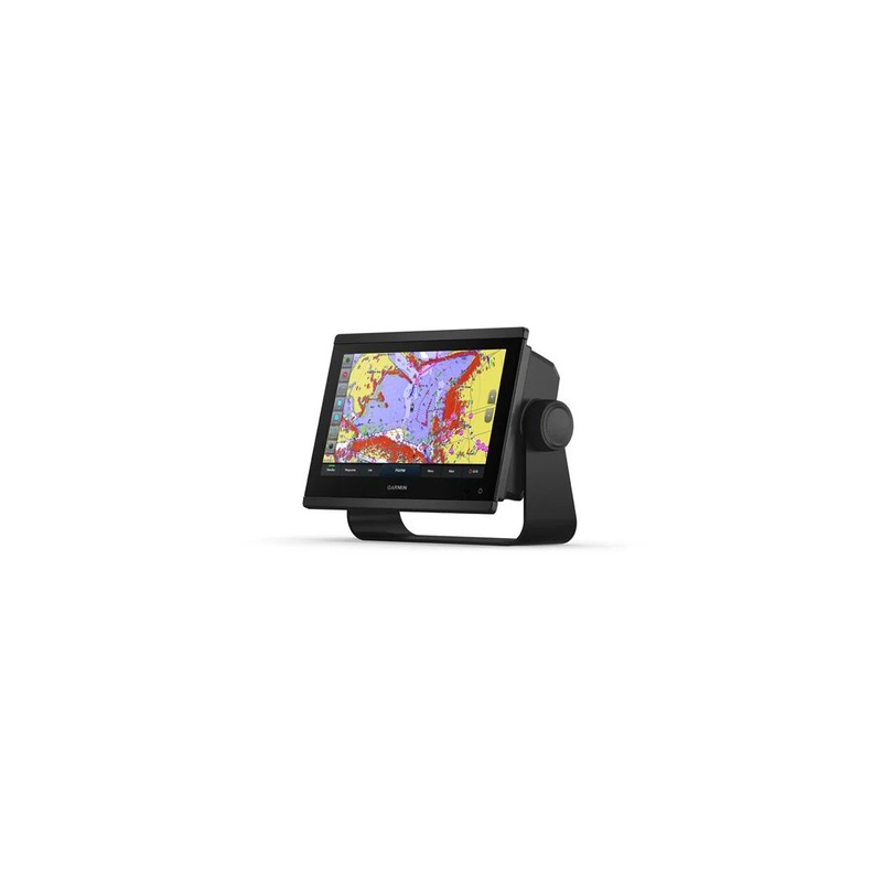
The 9 Garmin GPSMAP923xsv Touchscreen Chartplotter / Sonar / Depthfinder / Fishfinder Combo, with its sleek design, powerful processing and upgraded IPS display, integrates seamlessly into your Garmin marine system.The 9 Garmin GPSMAP923xsv Touchscreen Cha

The 9 Garmin GPSMAP923xsv Touchscreen Chartplotter / Sonar / Depthfinder / Fishfinder Combo, with its sleek design, powerful processing and upgraded IPS display, integrates seamlessly into your Garmin marine system.
The 9 Garmin GPSMAP923xsv Touchscreen Chartplotter / Sonar / Depthfinder / Fishfinder Combo, with its sleek design, powerful processing and upgraded IPS display, integrates seamlessly into your Garmin marine system.
The Garmin GPSMAP 923xsv 9 is an ultra high definition scanning sonar, with built-in Ultra High-Definition SideV and ClearV scanning sonars with vivid, high-contrast color palettes to help distinguish fish from structure. The GPSMAP X3 Chartplotter series also supports 1 kW traditional sonar capabilities.
It features the Traditional CHIRP Sonar function with Worldwide Basemap so you can see below your boat, with built-in sonar capabilities on select models.
The 7 Garmin GPSMAP 723xsv comes with the GarminGT51M-TM transducer.Perfect for the coastal and offshore fisherman who want CHIRP traditional sonar, CHIRP ClearV and CHIRP SideV scanning sonar, this transom mounted transducer consistently displays clear and crisp fish arches with superior target separation as well as clear pictures of objects, structure and fish that pass below and to each side of your boat and is optimized for rough sea conditions.
Traditional Sonar
Using powerful sound waves to ping objects in the water below, Traditional Sonar translates the echoes from those waves, into the images of fish, structure and bottom depths, you see on your display. This type of pulse, or signal may be high in power, but its short in duration. This limits the total amount of energy that can be transmitted into the water column below. The cone-shaped beam, of the typical sonar transducer, is approximately 40 degrees, or less. However, this signal expands the farther it travels in the water column, so the cone of coverage it produces on the bottom of a lake can be quite large.
Different frequencies reveal different levels of detail. For example, higher-frequency sonar is best at providing clear views of fish and structure in shallower water situations. Conversely, a low-frequency pulse can penetrate deep water but provides less imaging detail. To provide a more balanced combination of depth and detail, most traditional sonars now use a dual-frequency transducer for coverage thats easier to translate.
Scanning Sonar
Scanning sonar technology, uses high-frequency pulses, to give you a detailed, photo-real representation of fish and structure in the water below. Instead of a cone-shaped beam, Garmin scanning sonars use a narrow beam of very high-frequency energy, to create extremely detailed, digitally composed sonar images.
Garmin chartplotters and transducers are available with two main types of imaging: ClearV and SideV scanning sonars. The difference between the two is that ClearV is down-imaging sonar, designed to show a high level of detail in a narrow window under the boat, while SideV, as the name implies, is side-imaging sonar covering larger areas of water, to either side of your boat. Thus, ClearV generates detailed images of what is below the boat, while SideV covers a larger viewing area around your boat. Its useful for identifying bottom features, structure and cover where the best fishing spots may be found.
SideV
ClearV
Included in the Box:
Download here the English Owners Manual.
| Technical Characteristics | |
|---|---|
| Dimensions | 23.3 x 16.2 x 7.6 cm |
| Weight | 1.6 kg |
| Screen Size | 19.9 x 11.2 cm / Diagonal 22.9 cm |
| Display Resolution | 1280 x 720 pixels |
| Display Type | WXGA (Touchscreen) |
| Water Rating | IPX7 |
| Can be used with Polarized Glasses | Yes |
| Power Consumption |
Maximum Power at 10 VDC: 22 W Current Draw at 12 VDC: 1.3 A Maximum Current Draw at 12 VDC: 1.8 A |
| Antenna | Internal or External with NMEA 2000 |
| Receiver | 10 |
| Garmin Marine Network Ports | 2 |
| Power Output | 1 KW nominal / 1 KW CHIRP |
| Maps & Memory | |
|---|---|
| Accepts Data Cards | 2 microSD cards (back of unit) |
| Waypoints | 5000 |
| Track Points | 50,000 points / 50 saved tracks |
| Navigation Routes | 100 |
| Chartplotter Features | |
|---|---|
| Garmin Smart Mode Compatible | Yes |
| AIS | Yes |
| DSC | Yes |
| Supports FUSION-LINK Compatible Radios | Yes |
| GSD Black Box Sonar Support | Yes |
| GCV Black Box Sonar Support | Yes |
| Active Captain Compatible | Yes |
| GRID (Garmin Remote Input Device) Compatible | Yes |
| Wireless Remote Compatible | Yes |
| Sailing Features | Yes |
| Sonar Features | |
|---|---|
| Displays SONAR | Yes |
| Traditional SONAR (Dual Frequency / Beam) | built-in (single channel CHIRP, 70/83/200 kHz, L, M, H CHIRP) |
| ClearV | built-in 260/455/800/1000/1200 kHz |
| SideV | built-in 260/455/800/1000/1200 kHz |
| Panoptix SONAR | Yes |
| Livescope | Yes |
| Connections | |
|---|---|
| NMEA 2000 Compatibility | Yes |
| Transducer Port | 12-PIN (orange) |
| NMEA 0183 Input Port |
1 |
| NMEA 0183 Output Port | 1 |
| VIDEO Input Port | 1 BNC |
| VIDEO Output Port | 1 HDMI |
| ANT+ Connectivity | Yes |
| J1939 Ports | Yes |
Reviews
There are no reviews yet.